How to Read River Levels and Plan Around Somass River Flooding in Port Alberni

Why Port Alberni Residents Need to Monitor the Somass River
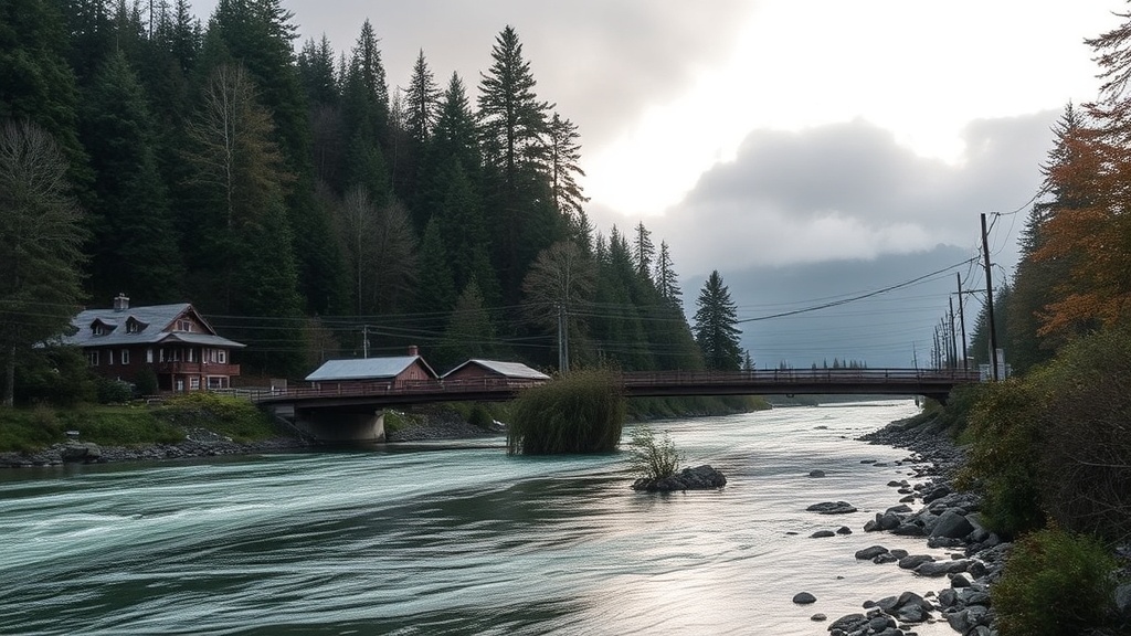
Here's something that catches newcomers off guard—Port Alberni sits at the head of the Alberni Inlet, where the Somass River meets the sea, and our community experiences seasonal flooding that can disrupt daily life more than almost any other natural event in the region. The Somass River system—which includes the Stamp River and Sproat River flowing into our valley—can rise dramatically during fall storms and spring snowmelt, turning familiar streets like Johnston Road and lower portions of Third Avenue into challenging passages. For those of us who live here year-round, understanding how to read river levels and prepare for high-water events isn't just handy knowledge—it's a practical necessity that affects commuting, property management, and community safety.
The geography of Port Alberni makes us particularly vulnerable. Our city sits in a narrow valley surrounded by mountains that drain into the Somass River basin. When heavy rains hit the west coast of Vancouver Island—or when warm spring weather rapidly melts the snowpack in the Beaufort Range and surrounding high country—that water funnels directly through our community. The Somass River flows through the heart of Port Alberni, passing near neighbourhoods like Lower Third Avenue, the Redford Street area, and sections of North Port before emptying into the Alberni Inlet. When water levels spike, the impacts ripple through our entire community—from road closures to park inundation to basement flooding in low-lying homes.
Where Can I Check Current Somass River Levels in Port Alberni?
Staying informed starts with knowing where to look. The Government of Canada operates a real-time hydrometric station on the Somass River near Port Alberni that provides current water levels, flow rates, and historical data. This information is freely available through the Water Survey of Canada website, which updates throughout the day during critical periods. Bookmark this page on your phone—when November storms roll in or during spring runoff in May, you'll want quick access to these numbers.
Local knowledge matters just as much as official data. The City of Port Alberni's official website and social media channels post flood advisories and road closure information specific to our streets. During significant events, the city activates its emergency notification system—sign up for these alerts through the city's website if you haven't already. The Alberni Valley Emergency Management team also coordinates with the city to provide updates, particularly when flooding threatens infrastructure like the Johnston Road bridge or access to neighborhoods along the Somass River corridor.
Understanding what the numbers mean takes a bit of practice. The Somass River near Port Alberni typically flows at around 100-150 cubic metres per second during normal conditions. When levels climb above 300 cubic metres per second, low-lying areas begin experiencing issues. At 500+ cubic metres per second, we see significant flooding along the Somass River pathway, potential road closures on sections of Third Avenue and lower Argyle Street, and water encroachment on properties near the riverbanks. Historical peaks—like the major flooding events Port Alberni experienced in the 1990s and more recently in 2014—have pushed flows well above 800 cubic metres per second, causing widespread disruption.
What Should I Do When Flooding Threatens My Port Alberni Neighborhood?
Preparation starts before the water rises. If you live in flood-prone areas of Port Alberni—particularly the Lower Third Avenue neighborhood, sections of Redford Street near the Somass River, or properties along the riverbank between the Paper Mill and Victoria Quay—keep sandbags and plastic sheeting on hand during flood season (typically October through April). The City of Port Alberni provides free sandbag filling stations when flooding is imminent; watch local announcements for locations, which are often set up at the Public Works yard or the Coombs Fairgrounds area.
Know your evacuation routes before you need them. If you live in the lower-lying sections of North Port or near the Somass River flats, familiarize yourself with alternate routes to higher ground. The main Johnston Road bridge can become impassable during severe flooding, so understanding how to reach the upper city via Gertrude Street or 10th Avenue connections becomes critical. Keep your vehicle fueled during storm warnings—Port Alberni's remote location on Vancouver Island means power outages can affect gas stations, and you don't want to be caught with an empty tank when evacuation routes are limited.
Protect your property with practical measures that work for our Port Alberni climate. Move valuable items from basements during flood warnings—many homes in our older neighborhoods, particularly those built before the 1970s near downtown and the Somass River corridor, have basements that flood repeatedly. Install backflow valves on sewer connections if you live in low-lying areas; when the Somass River rises, it can overwhelm our municipal drainage systems. Document your belongings with photos before flood season—if you need to make an insurance claim after a Port Alberni flooding event, having pre-existing documentation speeds the process considerably.
How Can Our Community Build Resilience Against Future Somass River Flooding?
Individual preparedness connects to broader community resilience. Port Alberni has made significant investments in flood mitigation over the past two decades—upgrades to the Somass River dike system, improved drainage infrastructure in the Third Avenue corridor, and better emergency response protocols. But climate patterns are shifting on Vancouver Island, and we're seeing more intense rainfall events that challenge even upgraded systems. Engaging with the city's floodplain management planning—public consultations happen periodically and are announced through the City of Port Alberni website—ensures resident voices shape infrastructure decisions.
Neighborhood networks matter enormously during flooding events. In Port Alberni's tight-knit communities—whether you're in Maquinna, Cherry Creek, or the Southport area—knowing your neighbours and establishing check-in protocols can save lives. Elderly residents, those with mobility challenges, and families with young children may need assistance during evacuations. The Alberni Valley has a strong tradition of mutual aid during emergencies—the 2014 flooding saw residents from higher-ground neighborhoods helping those affected along the Somass River with sandbagging, temporary housing, and supply runs. Building these relationships during calm times pays dividends when the river rises.
Long-term planning for Port Alberni means thinking carefully about where we build and how we develop. The city's Official Community Plan addresses floodplain development, but individual property owners should understand their own flood risk. If you're considering purchasing property in Port Alberni, check floodplain maps available through the city planning department—areas that seem idyllic during summer months may become liabilities during winter storms. For existing homeowners in flood-prone zones, improving utilities (furnaces, electrical panels, hot water tanks) above potential flood levels represents a significant but worthwhile investment that protects against the recurring reality of Somass River flooding.
Living with the Somass River means accepting both its beauty and its power. The river defines our valley, supports our local salmon runs that sustain our cultural and economic heritage, and creates the stunning landscapes that make Port Alberni distinctive. But it also demands respect and preparedness. By monitoring water levels, preparing our properties, knowing our evacuation routes, and building strong community networks, we transform from potential flood victims into resilient neighbours who can weather the storms that roll off the Pacific and into our valley. The Somass River will flood again—that's the reality of our geography. How we respond, individually and collectively, determines whether those events become manageable inconveniences or life-altering disasters for our Port Alberni community.